

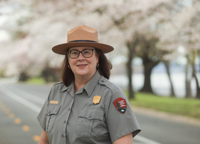
WASHINGTON— Tanya Gossett has been selected to serve as the new superintendent for Harpers F…
WASHINGTON— Tanya Gossett has been selected to serve as the new superintendent for Harpers F…
We are delighted to share the news, about the transformation of Civil War News! After five decades of delivering captivating and thorough Civil War narratives to our audience in the form of a newspaper, we are now shifting to a bi-monthly magazine format. This change signifies more than a ph…

Gettysburg, Pa. – National Park Service (NPS) Deputy Regional Director Cinda Waldbuesser today announced the selection of Kristina (Kris) Heister as the superintendent for Gettysburg National Military Park and Eisenhower National Historic Site. Heister has worked at Gettysburg and Eisenhower…
Fredericksburg and Spotsylvania NMP Project to Remove Non-Historic Structures and Rehabilitate Historic Landscapes
Petersburg, Va. – Pamplin Historical Park & The National Museum of the Civil War Soldier is holding a 159th Breakthrough Battle Anniversar…
The Mariners’ Museum to Commemorate the 162nd Anniversary
Join us at the National Museum of Civil War Medicine on Saturday March 2 at 2:00 PM as Alexandria historian Madeline Feierstein will explore t…
Fort Oglethorpe, GA—The National Park Service announced that 400 national parks reported a total of 325.5 million visits in 2023, an increase …
The National Museum of Civil War Medicine is proud to announce the 1st Saturday Speaker Series for 2024. The series will feature guest speaker…
Special Opening of Children of Gettysburg 1863®

The Battle of Aiken reenactment will celebrate its 30th anniversary on February 24th and 25th. The event was the 1995 brainstorm of Fred Cota …


The Military Memoirs of a Confederate Line Officer: Captain John Reed’s Civil War from Manassas to Appomattox, edited by William R. Cobb, was …

Whether Union or Confederate, all soldiers were civilians before they were in the military, and all of them wore shirts. While seemingly simpl…

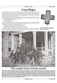
For two days in late August, substantial forces came together in the beautiful Pennsylvania countryside around Gettysburg in a struggle that w…

FREDERICK, Md.— Join archaeology lovers around the world in celebrating International Archaeology Day. The Archaeological Institute of America…
New report shows visitor spending supports 19,652 jobs in Tennessee
Chickamauga and Chattanooga National Military Park and Outdoor Chattanooga Continue Chickamauga Battlefield Bicycle Tours in 2023

The Artillery and Brigades of Antietam Speaker Series:

Gettysburg, Pa. (July 13, 2023)—Join the Gettysburg Foundation at the Gettysburg National Military Park Museum & Visitor Center Saturday, …

FRANKLIN, TN—Civil War battlefield preservation advocacy group, Franklin’s Charge, recently honored James Lighthizer, former president of the …